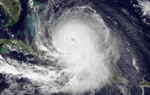
Category 4 Hurricane Joaquin on October 1, 2015, as viewed by GOES-13. Photo: NOAA
The meteorology models regarding the path of Hurricane Joaquin differ greatly, with some saying it will make landfall in the Carolinas/Virginia or north of there and others saying it will turn and head out into the Atlantic. Astrometeorology can be a real asset in pinpointing the direction/landfall of a hurricane.
Based on the autumn ingress chart and the October 4, 2015 lunar phase chart, Joaquin appears to be headed for the northeast, with landfall in Maine/Canada. Saturn (overcast, cool, storms) and Neptune (precipitation, flooding) are prominent there in the ingress chart, and Neptune is prominent in the lunar phase chart. The lunar phase chart also has a Mars-Neptune opposition – a classic hurricane aspect.
So this weekend’s scheduled race at Dover is likely to be rescheduled because of the effects of Joaquim. Will it be Monday? Maybe. Tuesday? More likely. Monday depends on the rain stopping in time to dry the track and run at least half the laps before sundown – iffy, at best.
Be sure to check out the Autumn Forecast, a seasonal overview of the next three months.